
Creek Area De Schelphoek - Nature
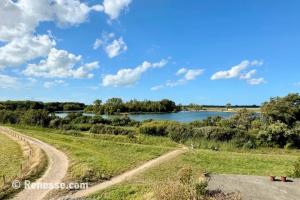
The Schelphoek is located near Serooskerke, on the southern side of the island.
- Formation: Created by a major dike breach during the North Sea Flood of 1953, forming a deep inlet.
- Nature reserve: Now protected and managed by Staatsbosbeheer, featuring a mix of creeks, mudflats, salt marshes, and woodland.
- Bird area: An important breeding and resting place for waders, ducks, and migratory birds; in winter often home to thousands of geese.
- Peace and quiet: Relatively unknown to tourists, allowing you to experience nature in tranquillity.
- Heritage: Together with Ouwerkerk and the Watersnoodmuseum, it forms a memorial landscape dedicated to the 1953 disaster.
Practical Information
- Parking: Along the Serooskerkseweg there is a spacious car park directly at the entrance to the nature reserve. You will also find an information point with several panels explaining the history and natural environment.
- Routes: A popular route is the 4-kilometre walk around the creek, marked with red posts.
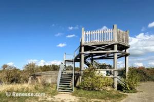
Furthermore Creek Area De Schelphoek is near the following sights: Viewing tower Schelphoek (±0 m), Prunjehil (±1,7 km), De Prunje (Prunjepolder) (±1,9 km), Plompe Tower (±2,5 km) & Plan Tureluur (±3,1 km).
For information
Schelphoek, Serooskerke (Schouwen)